LIBRARY
Natural Disasters: Earthquakes
eBooks
-
Historical seismology: Interdisciplinary studies of past and recent earthquakes byISBN: 1402082223Springer, c2008.
-
California earthquakes: science, risk, & the politics of hazard mitigation byISBN: 0801873606Johns Hopkins University press, 2001
Print Books in the Library
-
Global Tectonics by
Call Number: QE511.4 .K43 2009ISBN: 1405107774" ... a comprehensive introduction to all aspects of global tectonics." -
Plate tectonics: an insider's history of the modern theory of the Earth by
Call Number: QE511.4 .P569 2003ISBN: 0813341329Publication Date: 2003"(T)hese authors impart the excitement, contention, and competition of overturning accepted but erroneous science." -- [Booklist]
Useful Websites
-
Haiti Earthquake 2010Facts, Engineering, Images and Maps
-
National Library of MedicineDisaster Information Management Research Center
-
Pan American Health Organization [PAHO]PAHO and World Health Organization. Haiti Earthquake Health Q & A
-
Research Foundation of the State of New YorkChina (Sichuan Province) Earthquake 2008: News & Statistics. Includes many Weblinks.
-
University of NebraskaInformation on Haiti Disaster and Response
-
US Geological Survey Earthquake Hazards ProgramIncludes maps and latest information about earthquakes worldwide.
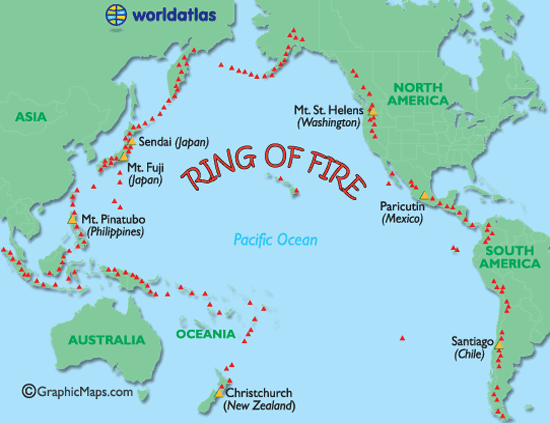
Ring of Fire

The Pacific Ring of Fire (or sometimes just the Ring of Fire) is an area where large numbers of earthquakes and volcanic eruptions occur in the basin of the Pacific Ocean. In a 40,000 km (25,000 mi) horseshoe shape, it is associated with a nearly continuous series of oceanic trenches, volcanic arcs, and volcanic belts and/or plate movements. The Ring of Fire has 452 volcanoes and is home to over 75% of the world's active and dormant volcanoes.[1] It is sometimes called the circum-Pacific belt or the circum-Pacific seismic belt. [Wikipedia]
See also USGS map http://pubs.usgs.gov/gip/dynamic/fire.html
Interesting Earthquake Facts
Before electronics allowed recordings of large earthquakes, scientists built large spring-pendulum seismometers in an attempt to record the long-period motion produced by such quakes. The largest one weighed about 15 tons. There is a medium-sized one, three stories high, in Mexico City that is still in operation. [USGS]
-
New Madrid BicentennialSeveral of the largest historical earthquakes to strike the continental United States occurred in the winter of 1811-1812 along the New Madrid Seismic Zone, which stretches from just west of Memphis, Tennessee into southern Illinois.
Richter Magnitude Scale
Because of the logarithmic basis of the scale, each whole number increase in magnitude represents a tenfold increase in measured amplitude; in terms of energy, each whole number increase corresponds to an increase of about 31.6 times the amount of energy released, and each increase of 0.2 corresponds to a doubling of the energy released.
-
Richter ScaleWikipedia
Earthquakes US Summer 2011
 Central Virginia Seismic Zone
USGS
Liquefaction
Earthquake liquefaction, ... is the process by which saturated, unconsolidated soil or sand is converted into a suspension during an earthquake. The effect on structures and buildings can be devastating, and is a major contributor to urban seismic risk. [ScienceDaily]
In the Christchurch Earthquake "... sandy soil was shaken violently, causing water to rise through its pores. Scientists compared it to jumping on wet sand at the beach - it soon turns to a murky soup." [nzherald.co.nz Feb. 23, 2011]
A sand volcano after the Christchurch earthquake. Photo / NZPA
China -- Earthquakes
-
Earthquake in China / Christian Science MonitorChina earthquake left at least 400 people dead and 10,000 injured. April, 2010.
